Regarding the early cultivation of Taiwan, apart from the 14 mountain tribes that are familiar to the public, the Pingpu people were those who cultivated the flatlands. In Tainan and the south of Tainan, it was the Siraya, a Pingpu indigenous tribe, who cultivated the area. Sinicization of the district began when the Chengs settled down here. After mud brick houses were gradually replaced by buildings with a red tile roofs, the place was renamed "Hongwacuo" to signify this change. In addition, as increased immigrants from Fujian migrated to this place, local buildings displayed a strong Fujian influence.
When the Chengs began cultivating Taiwan, they built a school in Baoxi Village to educate their people. As many talents were attracted to this place, they renamed it "Gueiren", meaning "benevolence for all."
In the southwest of Tainan City, north of the Erren River, a tributary Xuxian River bisected the city from east to west. During the reign of the Chengs, the district was under the jurisdiction of the Gueiren Village. During the Japanese colonization, the colonial government combined Nanbao, Yaoqinguan, and Liujia into Gueiren South Village and Houshizi, Xulocuo, Yangcuo, Kandongcuo, Hongwacuo, Xishizi, and Gucuo into Gueiren South Village.
As one of the "five wards in Xinfeng District", the Gueiren District sits in the southwest of the Xuxian River (also Xukuan River) located south of the district and north of the Erren River. It borders the Guanmiao District on the east and is separated from the Alian District of Kaohsiung City in the south by the Erren River. It borders Rende District in the west and sits on the border with Yongkang and Xinhua districts in the north. The entire district lies on a flatland occupying a total area of 55.7913km2, with a total of 17,879 households and a population of about 66,000 people.
Gueiren was cultivated by the Xinkang sect of the Siraya. The exact location is around what is today's "Jiushe Street", east of Yangcuo Village, Kandong Village. In addition, two clans, the Chens and the Lis, cultivated the south of what is today's Gueiren Elementary School. As they built houses with a red tile roof, the area was called "Hongwacuo." During the reign of the Chengs, the area was part of "Gueiren Village", meaning "everything goes to benevolence." The administrative planning was followed by the colonial government at the beginning of colonization. During the administrative district reform in 1920, however, the Village was renamed as "Gueiren Village" under the jurisdiction of Xinfeng District in Tainan Prefecture. The district was renamed "Guieren Township" in postwar Taiwan and finally "Gueiren District" on December 25, 2010.
Located southeast of the Jianan Plain in the Erren River valley, Gueiren is the southern-most district of Tainan City. It borders Guanmiao District in the east, Rende District in the west, and Yongkang and Xinhua districts in the north, and overlooks the Alian and Luzhu districts of Kaohsiung City. Zhongshan Road bisects the district from east to west and Zhongzheng Road runs across north and south intersecting at Gueiren Circus, the only circus (roundabout) on Nanguan Highway. After the opening of Longqi Highway, Gueiren has become the only passage between Neimen and Qishan in Kaohsiung, making the district the most promising spot for tourism development in Tainan City.
|
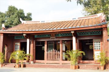
The story of Hongwacuo in Gueiren.
|
Gueiren was called "Hongwacuo" because most of the old buildings had a red tile roof. At that time when huts were very common, the living environment in Gueiren was exceptionally advanced even then.
Walking in Gueiren today, we can still see a strong ancient flavor in the modern time. Although there are many stories for the origin of "Hongwacuo", they can be summarized into three:
(1) A very old building stands in Gueiren Village—the Chens Ancestral Shrine. It is magnificent and has a crimson tile roof. Amazed by this grand red-roof building, people called it "Hongwacuo". As time went by, locals called the Gueiren "Hongwacuo" instead.
(2) The second version is quite close to the previous one. The only difference is that the red-roof building is emphasized as the place of the Chens' Ancestral Shrine in this version. This suggests that the red-tile roof was very common among the buildings in Gueiren.
(3) During the Kingdom of Tungning, after official Chen Yong-huaC established a school to educate their people in Basi Village, more and more people migrated to the district and built closely spaced red-tile-roofed buildings there. People thus called Basili "Hongwacuo".
From the above stories, it is clear that Gueiren was a well developed and wealthy place even in the earlier times. It is said that when Emperor Jiaqing of the Ching dynasty visited the district for travel. Whether true or not, people still take delight in talking about it.
Gueiren Village was called Shenei. The period after the last Kingdom of Tungning was called the Hongwacuo Period as red-tile-roofed houses were extensively built in the district. As the area where the current district office, market, nursing school, and police station were located was the CBD of Guiren Township, many buildings were built in the Japanese style. The Presbyterian Church in Taiwan built in 1906 next to the Confucius Temple named by the township name was a building in the English style. Inside the Village there are Xiangguozhaizi and Zhuangtou.
Xiangguozhaizi: It was named this way as cultivator Chen grew fruit trees here.
Zhujian: It was named this way because it was a slaughterhouse during the Japanese colonization.
|